The Best Esperance Hikes

Exploring the region around Esperance

The Esperance region, renowned for its white-sand beaches and turquoise waters, is more than just a beachgoers paradise. It is also home to some of the best hikes in Western Australia, with countless trails of varying length and difficulty.  Whether you’re a seasoned bushwalker or a nature enthusiast looking for a unique adventure, here are some of the best Esperance hikes.

Esperance

What Is the Best Time to Hike in Esperance?

The Esperance region offers the best conditions for hiking during the dry season, which typically runs from September to May. This is when the weather is at its most pleasant and there are low chances of rain, making the trails easier to navigate. However, it is essential to check the weather conditions before embarking on any hiking adventure and avoid challenging trails in wet and windy weather.

Learn more about the best time to visit the region in our guide to Seasons in Esperance.

Easy Trails

Stokes Heritage Trail

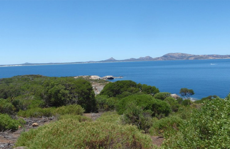
The Stokes Heritage Trail, just a short one-hour drive from Esperance, is one of the easiest hikes you can do in the region. The trail starts at Benwenerup Campground and finishes at the Stokes picnic area, offering breathtaking views of the Stokes Inlet on the way. Stokes National Park features one of Western Australia’s most picturesque estuaries and you can watch the diverse bird population from the trail’s observation deck. The park is also home to an abundance of other native wildlife, including kangaroos, honey possums, and emus.

Distance: 6.4 km (3.9 mi) return

Time: 1.5 - 2 hours

Difficulty: Easy

Suitable for: All ages and fitness levels

Starting point: Stokes Inlet Roa

Stokes Heritage Park

The Great Ocean Pathway

The Great Ocean Pathway is one of the most iconic walks in Western Australia that stretches along the Esperance coastline on the south side of town. Highlights include the pristine Blue Haven Beach and Tanker Jetty, in addition to expansive ocean views along the way. This gentle hike is suitable for all levels of fitness and is popular with local walkers, as well as runners and cyclists. If you're in search of a relaxed and leisurely stroll, you can join the trail at any point and complete shorter sections instead of doing the entire hike.

Distance: 17 km (10.5 mi) return

Time: 2 - 9 hours, depending on the trail 

Difficulty: Easy to moderate

Suitable for: All ages and fitness levels

Starting point: Tanker Jetty at Esperance Bay

Len Otte Nature Trail

Located within Cape Arid National Park, just a short drive out of town, the Len Otte is Western Australia’s first nature trail. This rewarding hike takes you through a fascinating landscape of rugged granite rock formations and offers stunning views of Thomas River and Yokinup Bay. Along the way, you’ll encounter a rich array of native flora, including yellow hibbertia, golden banksia, and scarlet honey myrtle. 

Distance: 1 km (0.6 mi) return

Time: 1 - 2 hours

Difficulty: Easy

Suitable for: Most ages and fitness levels, but some hiking experience is required

Starting point: Thomas River Road

Kepwari Walk Trail

Woody Lake Nature Reserve or Kepwari—a local Aboriginal term meaning "place of moving water"—is conveniently situated on the outskirts of the town. The trail provides an educational experience about Esperance’s wetlands and is a must for anyone interested in the region’s history and natural beauty. This is an easy walk, suitable for hikers of all experience levels, including families with children.

Distance: 7 km (4.3 mi) return

Time: 2.5 - 3 hours

Difficulty: Easy

Suitable for: All ages and fitness levels 

Starting point: Lake Road or Windabout Way

Find other family-friendly activities in our guide on Things to Do in Esperance for Families

Moderate Trails

Island Top Walk Trail

The Island Top Walk Trail takes you on a picturesque journey through coastal shrublands, culminating in a gentle climb to the summit, where you can admire sweeping views of the Recherche Archipelago. Interpretive signs provide helpful insights into the island’s wildlife along the way. This is not a very difficult walk—the loop can easily be completed in under two hours. 

Distance: 2.1 km (1.3 mi) return

Time: 1 - 1.5 hours

Difficulty: Moderate

Suitable for: Most ages and fitness levels, but some hiking experience is recommended

Starting point: Rotary Lookout at Cape Le Grand National Park

Island Top Walk

Twiggy's Landing and Shearwater Lookout Walk

The picturesque Twiggy’s Landing Walk on Woody Island is a great way to soak up views of the surrounding islands. The trail leads past the clearing to the Shearwater Lookout, where you can spot native wildlife, such as flesh-footed shearwaters and crested terns. End your day with a sunset snorkel in the crystal-clear waters of Shearwater Bay.

Distance: 1 km (0.6 mi) return

Time: 30 min

Difficulty: Moderate

Suitable for: Most ages and fitness levels, but some hiking experience is recommended 

Starting point: Woody Island Visitors Centre

Cape Le Grand Coastal Trail

Another must-do when visiting Esperance, Cape Le Grand Coastal Trail takes you through a landscape of large granite outcrops along the region’s most beautiful beaches, including Lucky Bay, Hellfire Bay, and Thistle Cove. Although this trail is ideal for a multiple-day walk, it can be done in shorter sections:

  • The Grand Beach to Hellfire Bay (3 hours) - difficult
  • Hellfire Bay to Thistle Cove (2 hours) - difficult
  • Thistle Cove to Lucky Bay (1 hour) - moderate
  • Lucky Bay to Rossiter Bay (2 hours) - moderate

Distance: 17 km (10.5 mi) one way

Time: 9 hours - several days

Difficulty: Moderate to difficult

Suitable for: People with a high level of fitness and hiking experience

Starting point: Le Grand Beach to Rossiter Bay

Experience the beauty of the Esperance region on our Perth to Esperance Self-Drive Tour.

Difficult Trails

Frenchman Peak Walk Trail

Nestled in the southwest corner of Cape Le Grand National Park, Frenchman Peak Walk Trail is a great challenge for experienced hikers. While the peak is less than 300 m (984 ft) high, the steep slopes and uneven terrain mean it can take several hours to hike. A walk to the summit is rewarded with panoramic views over the National Park, the southern coastline, and the islands in the Recherche Archipelago. 

Distance: 3 km (1.8 mi) return

Time: 2 - 3 hours 

Difficulty: Difficult

Suitable for: People with a high level of fitness and hiking experience

Starting point: Base of Frenchman Peak

Frenchman Peak

Mt Arid Walk Trail

For anyone looking for a more challenging outdoor adventure, Mt Arid Walk Trail in the Cape Arid National Park is the perfect option. The trail takes you through rugged granite outcrops and native Australian bushland. The terrain is rough and steep, requiring a good level of fitness and hiking experience, but the panoramic views from the summit make it all worthwhile.

Distance: 4 km (2.48 mi) return

Time: 3 hours 

Difficulty: Difficult

Suitable for: People with a high level of fitness and hiking experience

Starting point: Mt Arid car park, accessible by four-wheel drive through Yokinup Bay

Tagon Coastal Trail

The Tagon Coastal Trail is another advanced hike within Cape Arid National Park. The trail of exposed granite winds through rugged landscapes and coastal heath. Bird lovers should keep their eyes peeled for endemic species, including hooded plovers, crested terns, and pied oystercatchers. This is also an excellent vantage point for whale watching between July and October.

Distance: 14 km (8.6 mi) return

Time: 4 - 6 hours 

Difficulty: Difficult

Suitable for: People with a high level of fitness and hiking experience

Starting point: The eastern end of Yokinup Bay (depending on the time of year, you may need to wade through a river to access the trail)

Tagan Coastal Trail

Peak Charles Trail

The Peak Charles Trail, tucked away within the Peak Charles National Park, offers a true adventure for experienced hikers. The trail is long and difficult, but reaching the summit provides a sense of breathtaking accomplishment—at 651 m (2,136 ft) above sea level, you’ll be greeted with spectacular views of the surrounding area. This hike can be done in shorter sections depending on your fitness level and weather conditions: 

  • Mushroom Rock Trail (0.5 hours) - moderate
  • Central Ridge Trail (1 hour) - difficult
  • Peak Charles Summit (1.5 hours) - difficult

Distance: 6.2 km (3.8 mi) return

Time: 6 - 7 hours 

Difficulty: Difficult

Suitable for: People with a high level of fitness and hiking experience

Starting point: Base of Peak Charles

Ready to plan your perfect Esperance vacation? 

You can get more inspiration from our Western Australia Road Trips and Australia Travel Blog or contact one of our Australia Travel Specialists to have an itinerary customised just for you.

Irma Vuckovic
By
Irma Vuckovic
: 7 Nov 2023 (Last updated: 7 Nov 2023)

Download Our Free AU Travel Guide

Get our free guide which is full of actionable tips and information about how to make the most of your time in Australia.


Pricing terms

The price is based on current exchange rates but is only an approximation. Please contact us for a final price