The Best Hikes in Alice Springs

Hiking the Larapinta Trail

The breathtaking beauty of the Red Centre landscape makes Alice Springs a wonderful destination for hikers looking for an authentic outback experience. Below, we take a look at the best places to hike in and around Alice Springs, from easy walks to challenging multiple-day treks

hiking the Larapinta Trail

Where Is Alice Springs?

Alice Springs is the only major town in Central Australia, located in the lower part of the Northern Territory known as the Red Centre. Although this region is best known for its arid landscape, there are plenty of picturesque trails suitable for both casual walkers and avid hikers. 

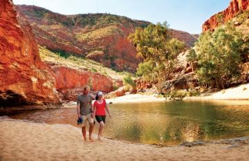
When Is the Best Time for Hiking in Alice Springs?

The best period to go hiking in the Red Centre is between May and September, when the temperatures are milder than the rest of the year. While it can still get very hot during the daytime, the mornings are usually cooler and temperatures rarely go above 30 °C (86 °F). Hiking in the height of the summer, from December to March, is not recommended unless you start your walk before the sun rises and finish before mid-morning.

Get more details on the weather and recommended activities in our articles on the Best Times to Visit Alice Springs, Things to Do in Alice Springs in Winter, and Things to Do in Alice Springs in Summer.

Easy hikes

Alice Springs to the Telegraph Station

Alice Springs Telegraph Station is a historical site built in 1872 as part of the Overland Telegraph Line which connected Australia to the rest of the world. The easy Riverside Walk north of the town centre will take you to the station in just under an hour. Keep an eye out for the wildlife along the way, including native wallaroos hiding among the rocks. If you’re up for a more challenging walk, continue on one of several trails that start at the Telegraph Station, such as the initial section of the iconic Larapinta Trail. 

Distance: 3.5 km (2.1 mi) each way

Time: 45 minutes

Difficulty: Easy

Family friendliness: Suitable for children

How to get there: Start at Todd Mall in Alice Springs and follow the path along the Todd River

Alice Springs Desert Park 

A must-see destination on any visit to Alice Springs, Desert Park provides insights into the diverse desert ecosystems of Central Australia and showcases the rich cultural heritage of the Aboriginal People. A shared walking and cycle path at Blain Street will get you to Desert Park through rugged terrain with granite rock formations, providing a glimpse into the stunning beauty of the Australian outback.

Distance: 7 km (4.3 mi) each way

Time: 1.5 hours

Difficulty: Easy

Family friendliness: Suitable for children

How to get there: Start at Blain Street off Larapinta Drive

Alice Springs Desert Park wildlife

Olive Pink Botanic Gardens

The Olive Pink Botanic Gardens offer several easy trails suitable for families with children. Take the 40-minute return Hill Walk up Annie Myer Hill for expansive views of the town, Todd River, and MacDonnell ranges. The walk is best done around sunset when native wildlife, including wallabies and kangaroos, is at its most active.

Distance: 1.4 km (0.9 mi) 

Time: 40 min

Difficulty: Easy

Family friendliness: Suitable for children

How to get there: The gardens are easily accessed on foot from the town centre along the Todd River.

Finke Gorge

Finke Gorge National Park is home to the Finke River, one of the oldest rivers in the world. The park has several easy scenic trails, including the walk to the Kalaranga Lookout that offers spectacular views of the surrounding landscape, Mpaara Walk where you can learn about the culture of the Western Arrernte People, and Arankaia Walk through the famous Palm Valley. Don't miss the majestic Red Cabbage Palms, a remnant from Australia’s ancient past when the Red Centre was covered in tropical rainforest.

Distance: Mpaara Walk 5 km (3 mi), Arankaia Walk, 2.6 km (1.6 mi)

Time: 1.5-2.5 hours

Difficulty: Easy

Family friendliness: Suitable for children

How to get there: Finke Gorge National Park is located 140 km (86 mi) southwest of Alice Springs and is accessible only by four-wheel drive. 

finke gorge national park

Uluru (Ayers Rock)

Nestled within the Kata Tjuta National Park, Uluru is the most popular destination in the Red Centre. Although climbing the monolith is prohibited, you can explore it along one of the six easy walks, including the 10 km (6.2 mi) base walk. Detailed information boards provide extensive information about the ancient landscape and the Anangu People who inhabit the region. 

Distance: Uluru Base Walk 10 km (6.2 mi)

Time: 3.5 hours

Difficulty: Easy

Family friendliness: Shorter walks are suitable for young children

How to get there: Begin the walk from the Mala Car Park

For more details, read our comprehensive Guide to Visiting Uluru.

Moderate hikes

Ormiston Pound Walk

The picturesque Ormiston Pound Walk is one of the best half-day hikes in the West MacDonnell Ranges, a scenic 90-minute drive from Alice Springs. The trail offers the opportunity to explore the region’s rugged landscape and its diverse flora and fauna. Keep in mind, however, that you will have to wade or swim through several waterholes which can be freezing cold, so be sure to check at the Visitor Centre what the expected water depth is before you head out. 

Distance: 9.5 km (5.9 mi) each way

Time: 2 hours

Difficulty: Moderate

Family friendliness: Not suitable for young children due to the rocky surface

How to get there: Start at the Ormiston Gorge Car Park; the walk is best done in an anticlockwise direction.

Ernest Giles Track

Ernest Giles Track is another picturesque hike within Watarrka National Park. This well-marked trail connects Kings Canyon and Kathleen Springs, known for its towering sandstone cliffs and a refreshing waterhole. This is a long, challenging walk and it is recommended to break it up and complete it as an overnight hike. If you prefer to do a shorter part of the trail, start at Kings Canyon and walk for about 5.5 km (3.4 mi) to Reedy Bluff, before returning the same way.

Distance: 22 km (13.6 mi) each way

Time: 7 hours

Difficulty: Moderate

Family friendliness: Not suitable for children

How to get there: You can reach Ernest Giles Track either via the Stuart Highway and the unsealed Ernest Giles Road or via the Finke River 4WD Route from Palm Valley. 

Kings Canyon Rim Walk

The iconic Kings Canyon Rim Walk is the most popular trail in the Watarrka National Park, around 360 km (223.6 mi) southwest of Alice Springs. The hike takes you along the top of the canyon, offering spectacular views of the surrounding landscape. Note that there is a very steep climb up 500 steps—nicknamed Heartbreak Hill—at the start of the walk and a steep descent at the end.

Distance: 6.5 km (4 mi) each way

Time: 2-3 hours

Difficulty: Moderate 

Family friendliness: Not suitable for children

How to get there: Start at the Kings Canyon Car Park and complete the walk in a clockwise direction.

Kings Canyon rim walk

Yeperenye Trail

Yeperenye Trail connects the scenic Emily and Jessie Gaps in the East McDonnell Ranges, considered to be key spiritual sites to the Eastern Arrernte Aboriginal People. In addition to taking a close look at the unique rock formations, the Yeperenye walk allows you to come up close to the Aboriginal rock art on the gorge walls. Just keep in mind that visitors are not allowed to touch or photograph the art.

Distance: 7.2 km (4.5 mi) each way

Time: 1.5-2.5 hours

Difficulty: Moderate

Family friendliness: Not suitable for young children

How to get there: The park is located 10 km (6.2 mi) east of Alice Springs, off the Ross Highway.

Learn more about Aboriginal culture on FLT’s Australian Cultural and Heritage Self-Drive Tours and Aboriginal Experience Tours.

Moderate to hard hikes

Trephina Gorge Walks

Trephina Gorge Nature Park has several walking trails of various lengths and difficulty. The Ridgetop Walk is a longer hike that offers expansive views of the ranges and all the way to Alice Springs from Turner’s Lookout. The Chain of Ponds Walk is a shorter but equally challenging trail with magnificent views of the gorge, while the Gorge Stroll is an easy 500 m (0.3 mi) walk to the semi-permanent waterhole located within the gorge.

Distance: 9 km (5.5 mi) each way

Time: 1.5-2.5 hours

Difficulty: Moderate to hard

Family friendliness: Gorge Stroll is suitable for children

How to get there: Trephina Gorge Nature Park is located 85 km (52.8 mi) east of town, off the Ross Highway. The last 5 km (3 mi) of the road are unsealed.

Larapinta Trail

There’s no better way to experience the Red Centre than hiking the iconic Larapinta Trail. Walk across the ancient landscapes of Australia’s outback through the West MacDonnell Ranges all the way to the summit of Mount Sonder, the highest mountain in the region. The trail passes over remote ridges and canyons and is suitable for experienced hikers, although it is possible to complete only shorter sections on a day trip.

Distance: 223 km (138.5 mi)

Time: 1-7 days

Difficulty: Moderate to hard

Family friendliness: Some shorter sections are suitable for children

How to get there: The trail begins at the Alice Springs Telegraph Station.

Larapinta Trail

Valley of the Winds Walk

The breathtaking Kata Tjuta, a group of 36 dome-shaped mountains, has several spectacular walking trails suitable for more experienced hikers. The challenging Valley of the Winds Walk meanders through the imposing red rock domes of Kata Tjuta and offers spectacular views of the Central Australian desert.

Distance: 7.4 km (4.5 mi)

Time: 3-4 hours

Difficulty: Moderate to hard

Family friendliness: Not suitable for children due to steep, rocky terrain

How to get there: Kata Tjuta is located within the Uluru Kata Tjuta National Park, around 40-minutes drive from Uluru.

Safety Tips

  • The Red Centre can get extremely hot during the day and sufficient sun protection is essential when hiking. Bring plenty of sunscreen, sunglasses, and a wide-brimmed hat to avoid being burnt by the harsh UV rays this region is known for.
  • It is essential to carry enough water and stay hydrated throughout the day. 
  • Nighttime temperatures can be freezing, so be prepared with extra layers if you’re planning an overnight trip. 
  • Some trails involve uneven, rocky surfaces and steep climbs. Be sure to choose the ones that match your experience and fitness level.
  • The Red Centre is home to numerous wildlife species. Respect their habitats and always maintain a safe distance.
  • Be sure to carry a first-aid kit and an emergency device, for example, a simple Personal Locator Beacon (PLB) or a satellite communications device. 

The Ideal Alice Springs Itinerary

Are you ready to plan your Alice Springs vacation? You can get more inspiration from our detailed itineraries, including Alice Springs Self Drive Loop and Alice Springs to Darwin Road Trip. Alternatively, you can get in touch with our Australia Travel Specialists to have an itinerary customised just for you.

Irma Vuckovic
By
Irma Vuckovic
: 20 Mar 2024 (Last updated: 20 Mar 2024)

Download Our Free AU Travel Guide

Get our free guide which is full of actionable tips and information about how to make the most of your time in Australia.


Pricing terms

The price is based on current exchange rates but is only an approximation. Please contact us for a final price